RUMOI PROFILE 1
![]()
|
● Profile -概要- ● |
|
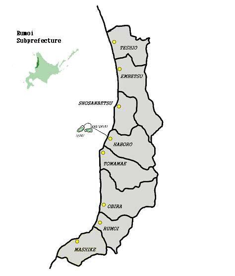
Topography Rumoi Subprefecture is located in the northwestern part of Hokkaido,facing west to the beautiful Sea of Japan. The Subprefecture, stretching 130 km north and south and 60 km east and west, consists of one city, six towns and one village. 地 勢 留萌管内は、北海道の北西部に位置しており、その西側は美しい日本海に面し、南北130km、東西60kmの南北に長い地域で、1市6町1村で構成されております。 Climate Rumoi’s climate is characteristic of the Sea of Japan area. Due to the Tsushima Sea current, it is relatively warmer than other places with similar latitudes. Furthermore, there is a two-degree difference in average temperature between north and south as a result of the vertically-stretching topography. 気 候 気候は、日本海岸式の気候であり、対馬海流の影響で緯度の割には比較的温暖ですが、南北に長い地形から北部と南部では平均気温で約2℃程の差があります。
|
|
|
● Nature -自然- ●
|
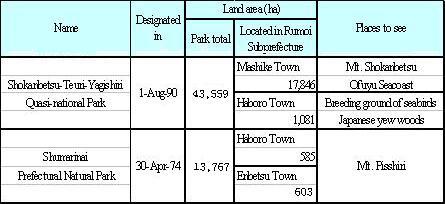
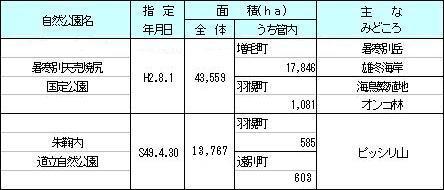
Natural Parks in Rumoi Subprefecture There are two natural parks including the Shokanbetsu-Teuri-Yagishiri Quasi-national Park. These parks offer visitors the opportunities to enjoy their spectacular natural landscapes and to watch invaluable flora and fauna.
自然公園の状況 管内には、暑寒別天売焼尻国定公園をはじめ2つの自然公園があり、美しい自然景観を楽しんだり、貴重な動植物などを観察できるようになっています。 |
|
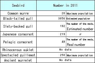
Numbers of Breeding Pairs or Individuals in Teuri Island Another of Japan’s natural habitats for special protection, Teuri Island is a breeding place of seabirds, including the common murre (in the Ororon Island), black-tailed gull, Japanese cormorant and rhinocerous auklet. 天売島における海鳥の繁殖巣数・個体数 天売島はウミガラス(オロロン鳥)をはじめとして、ウミネコ、ウミウ、ウトウなど8種の海鳥繁殖地として国の天然記念物に指定されています。 |
|